
"YOU ARE HERE" SIGNS
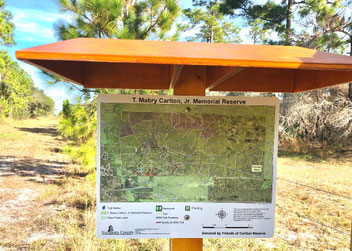
The Carlton Reserve is large (roughly 25,000 acres) and does not have a distinctive directional feature (mountain peak or river). People do get lost in the park. Volunteers have deployed “You Are Here” Signs/Maps at
12 key locations in the park. The locations are where there is a higher probability of people passing by if they become disoriented. Signs with maps were placed at these locations some time back, and the plan was deemed good. However, some changes in the map and in the quality of the signs was recommended. Professionally made signs and updated maps have now been located in the Carlton, and the Friends of Carlton Reserve paid for the professional signs. 12 signs are currently deployed. Attached is a photo of the sign post at marker #67 (the eastern entrance to the park) and of the source map included in that sign. The volunteers assist the County in many capacities related to recreational opportunities.
Trail Notes for Biking/Hiking updated 11/6/25
Backcountry trails are seasonally flooded but almost all trails are open. Hurricane debris removal from trails throughout the Reserve was delayed but trails are now clear and the the mowing schedule is underway. However, the danger of wildfire due to hurricane created fireload has the prescribed burn team working as fast as possible to protect the Reserve.
as been reconditioned, culvert work is ongoing.South Powerline h
WE CAN NOT CHECK EVERY TRAIL REGULARLY--WHEN WE HAVE INFORMATION, WE WILL POST IT HERE. CONTACT US VIA E-MAIL (Use contact link on right side of this page) TO OBTAIN TRAIL INFORMATION NOT POSTED HERE OR TO REPORT TRAIL CONDITIONS.
All trails beyond the handicapped access public area are multi-use trails. Please be courteous and safe to other trail users. Backcountry Trails may have hog damage--this makes bike riding difficult until rains settle the surface. but recent eradication programs are making good progress over years past. Most trails may also double as firebreaks and may have been disced by tractors or otherwise conditioned to expose the soil that may become sandy in places. Be alert to regular prescribed burns. Stay clear of burn personnel and equipment. Get burn schedule at Sarasota call center: 861 5000. We usually do not get notices until the morning of a burn--check our FaceBook site: https://www.facebook.com/CarltonReserve
Use the map link (below) to download the current trail map but be advised that trail conditions change daily with rains, hog rooting, wild and controlled fires, timber thinning, water utility maintenance, and powerline maintenance.
Problem Areas and Changes
The Venice Arcadia Grade is almost always passable except 1/4 mile before Windy Sawgrass Camp where the trail may be quite deep but passable on the grassy east side.
Rocky Ford Trail has two wetlands on the west end which are frequently wet. Use the cutover at 54 through the Homestead Campsite at 55 to access Rocky Ford. Trail may be flooded seasonally west of new pumping station between 12 and 53. The trail from 57 to 56 is no longer mowed or maintained.
Vicker’s Head Trail is frequently wet or flooded in places north from 19.
Light Blue cutover trail from red to power line is mowed but often wet.
Tiger Marsh area and east of Blackmon’s Camp is seasonally wet in the NE quadrant of the Reserve and may not have been mowed due to water on trail.
South Power line east of Mabry Carlton Parkway and Well Field Loop Road are in good condition.
Stockade Trail from 13 to 15 is mostly grassy but may be seasonally sandy or muddy. Stream crossings north of #8 and #9 may be seasonally wet.
Turpentine Trail, north from 20, is raised for the first mile. There are seasonally wet areas between 20A and 27.
Self-guiding trails are seasonally flooded.
South Border Trail between T. Mabry Carlton Parkway, Deer Prairie Slough and 67 has frequent hog damage and may be seasonally flooded or muddy.
Resources
The SWFWMD recreational map is available free. It covers Deer Prairie and other SWFWMD lands. Order from their web site. SWFWMD (Click on Recreation)
There are signs (placed by Eagle Scouts) on named trails to aide the public in navigating the Reserve.
Brochure with trail map is available in cabin or visitor kiosks.
Photograph kiosk map (both sides) with cellphone OR download maps here.
SWFWMD The SWFWMD recreational maps are free. Order from SWFWMD web site.
Florida Trails from Florida Trails Association
Florida Trails Network Interactive Trails Database for State of Florida with map viewer
President
Vice president
Jim Lombardi
Secretary
Richard Hullett
Treasurer
Website & Info:
Park Naturalist
Meghan Harris Meyer


Link to searchable U.S. map resources with parks, trails, campgrounds, historical sites, marinas, etc.

Sarasota County
Field Guide
to Conservation Lands
(download 64pp. PDF)
